Last year at a snowshoe race I met Nathaniel Rowley, co-owner of Sahaptin Outfitters in Cle Elum. His shop launched a fun hiking contest this summer called “Summit the District“: a challenge to summit 10 peaks in the Cle Elum Ranger District. I’m getting a pretty late start but trying to knock as many off the list as I can by the October 20th deadline.
My friend Annette is an outdoor animal and we have a track record of adventurous outings that never end up ordinary. Usually someone, either one of us or one of our 3 crazy dogs, ends up bloody. Last week we bushwhacked through Devil’s Club (Annette called it a trail) with our dogs in tow to a lake somewhere off I-90. It was a beautiful hike! But instead of blood we ended up with Devil’s Club rash.
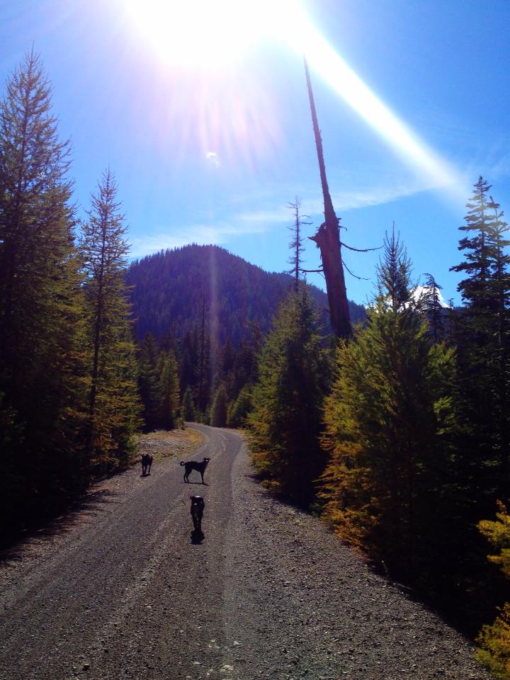
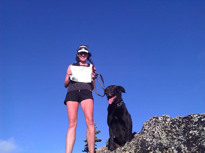
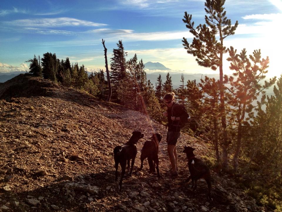
Yesterday I met Annette in North Bend so we could cross off one of the Summit the District peaks. When she said “I have this idea…” I knew we were in for a full day. She suggested we hike Mt. Clifty, a 13.6-mi journey called the most remote hike on the list. Perfect! Joining us of course would be my crazy 8-yr old Black Lab Jake and Annette’s twin 1-yr old pups Babs and Bruce.
First order of business: getting everyone into my Jeep. Turns out a bunch of dogs in a car together is step 1 for an exciting day. Before we could even get out of the parking lot Jake was barking and drooling everywhere with unbridled enthusiasm and Babs managed to jump straight out the rolled down passenger window. Bruce quietly tried to sort out how to share the backseat with a boisterous, 85+lb Jake. Once we got everyone into their assigned seats we headed east on I-90 to exit 93.
From Exit 93 you take a few turns to get to the Taneum. When the pavement ends it turns into FS Rd 33 and shortly after we made our first error and skipped through one of our turns. We figured it out a few miles up the road and turned around, but not before taking a little rest stop for us and the dogs to stretch. Instead of stretching, they ran through mud puddles and hopped back into the Jeep, coating me and the inside with mud everywhere. Ah, the reason I drive a 15-yr old Jeep!
Back on track, we followed FS Rd 3300 up past the South Fork Meadow Campground. We were supposed to cross a junction with FS Rd 114 and then find our trailhead (#1377) in another 4 miles. We kept driving, but no 114. Hmmm, did we miss it? Had we not gone far enough? We backtracked and looked carefully at cross roads. No signs, no 114. After going back and forth a few times we were sure we didn’t go far enough and continued up the road further. My gas tank read a little over a quarter tank, oops. Maybe gas would have been good before getting up here.
We continued driving until we saw a few cars parked alongside the road: promising! Then we saw a gate across the road. Shit. Our directions said nothing about a road ending gate. Now what? 2 friendly and helpful men nearby told us we were in the right spot. They pointed out Lookout Mountain directly in front of us and said Mt. Clifty was right behind it. Just up the fire road a little ways we could hop over to the trail to Clifty, just to our right along Taneum Creek. There were several places to access the trail from the fire road and if we hiked up a little further, we could avoid a big creek crossing. Excellent!
They also told us of their shelter a few miles in with supplies and food in case something happened and that we were welcome to use it. Very nice of them! Foreshadowing? Nah… We thanked them for their hospitality and geared up to hit the trail. Yay, we’re going to make it to Clifty afterall!
Quickly past the gate was the trailhead sign for #1377. Awesome! We remembered the guys telling us there was a big creek crossing and that we could hop over to the trail on up the fire road so what do we do? We skip the obviously signed trail and proceed up the fire road. It’s fast and we’re making great time! Hindsight is 20/20…
About 2.5 miles up the fire road bends to the left, clearly away from where we want to go. Crap. Will it bend back around? We trace the road in the distance and make the obvious decision to go all the way back down and just get on the actual trail we need. Duh, what were we thinking?
We find a small road a ways back that leads to a trail along the creek. We’re certain it’s our trail #1377 but with no obvious signage and our current track record we decide the safest bet is to backtrack the mile or so all the way down until we see the trailhead sign to make doubly sure. The dogs are excited to follow but seem to be wondering why we’re going back and forth. They look at us as if to say, “Hmmm, I have a question?”
A short distance down the trail we hear the sound of approaching dirt bikes. The bikers stop and confirm we are indeed on #1377, the correct trail up to Mt. Clifty and bid us a fun afternoon as we turn back around (again) and officially start our hike. We’ve already done almost 5 miles with the entire 13-mi journey still left to go. Oops. Guess we’ll get our workout!
The trail is an easy upward grade and we clip along making great time, enjoying the beautiful old growth forest surrounding us. What an amazing area this is! The hike goes quickly and soon we’re standing at the junction of Windy Pass and trail #1326. We check our directions.
“Begin your ascent through Windy Pass for approx. 1 mile to the junction with Trail #1321.1”.
The trail signs are faded and you have to get close to read them. To our right isn’t really signed, but it looks like a trail up to a ridge that could possibly be Clifty, but with another 2.8 miles to the summit it doesn’t seem to compute. We look left, to what seems to be the most traveled trail. The peak straight up the left of us looks cliffy, and so we deduce it MUST be Mt. Clifty. Right?? Logical brains at work here! Does “through Windy Pass” mean left or right? We pick left. In one mile we should reach a junction with Trail #1321.1, so if we don’t, we know we picked wrong.
In short time we see a small junction with a sign but no 1321.1, so we continue. Soon we’re going downhill to the forest floor. Full stop, this doesn’t seem right. We shouldn’t be going down into the forest when we’re going up to a peak. What went wrong? We turn back (again).
We come back to that small junction. The sign reads “North Ridge TR” but no numbers. Hmmmm. Is that the 1321.1 trail we need? No idea. We start wondering if we shouldn’t go back to the Windy Pass junction and look closer at the signs to be sure we didn’t miss something. It’s closing in on 6pm and our summit time is getting limited. We’ll certainly be coming down in the dark with our headlamps that thankfully we packed. If we even make it!
We hike back to the Wendy Pass junction and as we’re standing there, trying to make sense of the trails, wishing we had actually brought a map, we hear the sound of motos. 2 guys pop onto the ridge and they tell us the small junction we stopped at IS indeed the trail. If we hike up it a short ways we’ll see a “Mt Clifty” sign with a “Most Difficult” trail icon. They tell us it’s a steep climb and at least another hour to the top.
With renewed confidence, we go back, take the North Ridge trail, and sure enough, there’s our Mt. Clifty sign a short ways after it. Turns out North Ridge TR is #1321, which takes you to the Mt Clifty trail (#1321.1) though there’s no #1321.1 anywhere to be seen. Only an arrow that says “Clifty”. We head up the steep jagged rocks and pop onto an exposed ridge where we see what finally seems to be the summit. Yes!
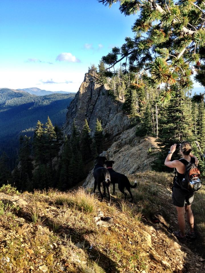
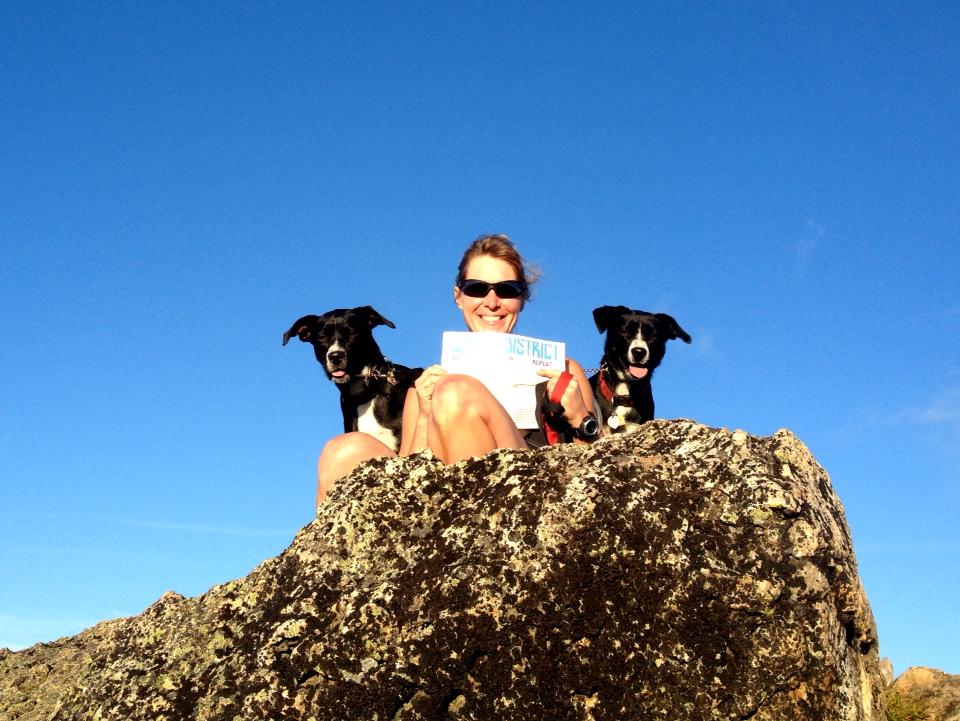
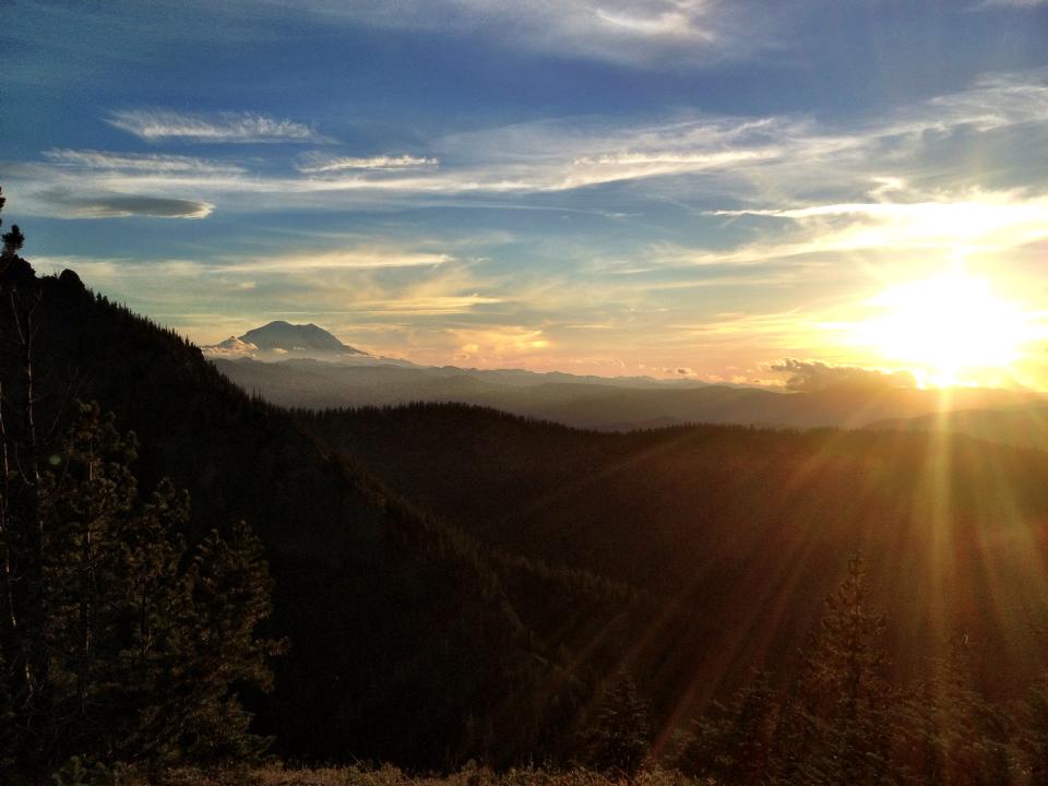
We get there, find no signs, and realize the trail continues down and to the right before heading back up along a ridge a little ways further to reach the actual summit. Once there we climb a little rock outcropping and find the register on the opposite side. The wind is fierce and freezes us almost instantly. We stop long enough to enjoy the stunning views, take some pics, and fuel up. We’re on top of the world with unlimited 360-degree views! You can see Mt Rainier to the south and Mt Stewart and the Enchantments to the north. This summit is amazing.
Our missteps pushed us to a late summit, which meant a bonus reward of being able to enjoy a beautiful sunset from the top of the ridge. Mt Rainier and the surrounding peaks sure put on a good show as we headed down shortly after 7pm.
Our journey down was much less adventurous than the journey up and aside from taking one minor wrong turn (which we promptly corrected) we proceeded down with little trouble. Halfway down we turned on the headlamps and I forgot how fun it is to hike out in the dark. It’s been ages!
As we neared the junction to the forest service road two approaching motos stopped to ask us if we were ok and to make sure all was well. With so much negative press surrounding ORVs, I have to say that our experience was nothing but positive. Every moto rider we met on the trail was incredibly kind, polite, and helpful.
After finding our junction back to the fire road and then hiking/jogging a very long last mile down it, we finally returned to the Jeep tired and happy. The dogs couldn’t wait to jump in and were asleep almost immediately. All total, we ended up clocking 19.5 miles and 4400′ of climbing.
Desperate for food and beer, we hit the road quickly, hoping something in Cle Elum would still be open. After nearly an hour drive back into town we were ecstatic the Cottage Cafe was still open and serving food at 10:30pm. We enjoyed a hard earned cold beer and the food tasted extra good after that long day. We laughed at ourselves with our wind-blown hair, dirty feet, and generally disheveled appearance. Another good adventure in the books!
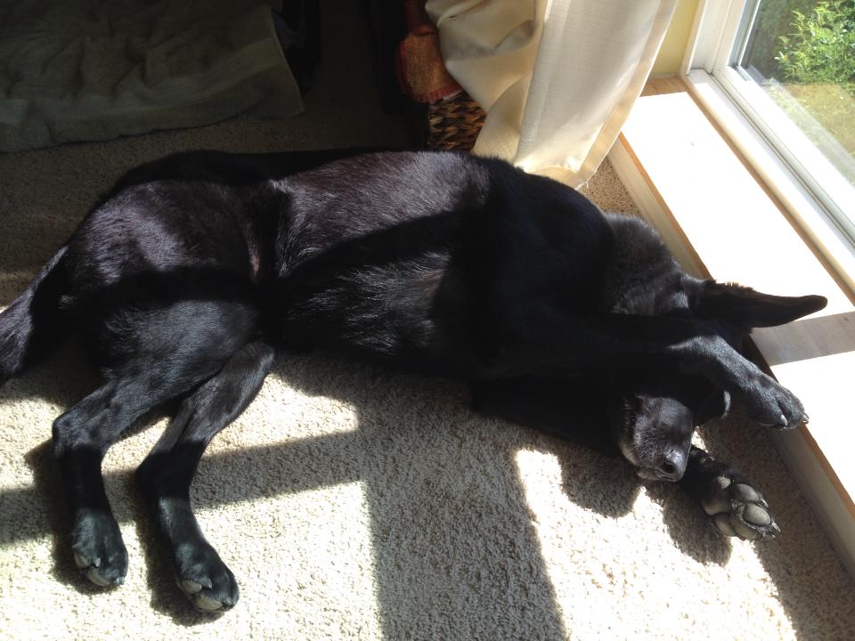
I finally got home around 1am and had to coax poor Jake out of the Jeep. Mt. Clifty took it’s toll. He’s been like this for nearly 24 hours:
All in all, Mt. Clifty is an amazing hike and one of the best I’ve done. Without Sahaptin’s contest we likely never would have gone there. Next time though we’ll definitely bring a map. Some of the signage on the trails didn’t seem to quite match up with our directions but a map would have easily shown the right trails to take. Big thanks to Sahaptin for creating the contest and also to the local moto crowd for helping us get to the top!
Can’t wait to see which one we do next…
Stats
Round Trip: Should have been 13.6, instead we did over 19 miles.
Elevation Gain: ~4,000′
High Point: 6,245′
Hiking Time: 6:30